How sampling Mushkegowuk peatlands supports Indigenous land stewardship
Canada is home to massive stores of carbon, and while most of us think about it being stored in trees, the majority is actually found underground — hundreds of billions of tonnes.
We know this because of our Mapping Canada’s Carbon Landscape project, which was recently released in partnership with McMaster University’s Remote Sensing Lab and used a machine-learning algorithm to predict terrestrial carbon stocks across the country.
While the algorithm took in all sorts of information — soil samples, satellite-based lidar, climate and topographic variables, and long-term satellite data — conducting field surveys will allow us to further refine the carbon map to identify the spots that must be conserved to prevent climate-altering levels of carbon from being released.
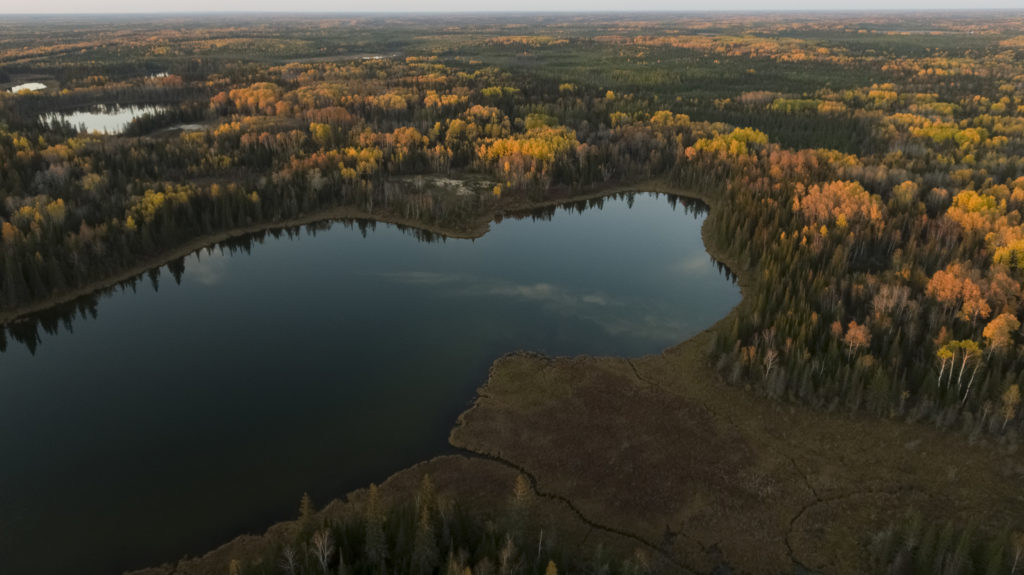
A great place to gather even more samples is in one of the globally significant areas of carbon storage identified in the study: the Hudson and James Bay Lowlands, which are covered in peatlands (a type of wetland where partially decayed plant matter accumulates).
At the global scale, there is twice as much carbon stored in peatlands than in forests and, when left intact, they are incredibly effective at storing carbon over long periods of time.
To help build our understanding of carbon in soil, WWF-Canada staff and partners from Mushkegowuk Council and McMaster University’s Remote Sensing Lab — along with community members representing Attawapiskat, Fort Albany, Kashechewan, Moose Cree and Weenusk First Nations — met in person in early September to receive training on sampling carbon in peatlands.
This field training is one of the first steps towards a series of community-led carbon sampling projects planned in Mushkegowuk territory. The hope is that this work will provide a clearer picture of the carbon storage provided by peatlands and guide the restoration and protection of these ecosystems. As an associate specialist with WWF-Canada’s Science, Knowledge & Innovation team, I had the opportunity to join.
Sampling Peat
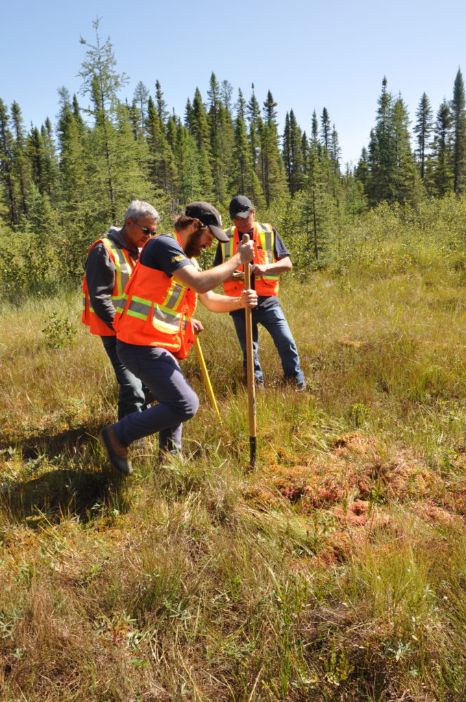
I travelled north to Timmins, Ontario with my colleague Will Merritt, a GIS specialist at WWF-Canada, for fieldwork training led by an environmental consulting company called Blue Heron Environmental.
We spent the first few days in the classroom learning best practices for conducting environmental fieldwork and reviewing the basics of using GPS units. Camile Söthe, a researcher from McMaster University and the lead author on the carbon mapping study (currently under peer review), provided an overview of sampling using peat corers. Before long, we got the chance to test out this equipment in the field.
After driving north on highway 655, we pulled off the road and headed out into the bush with our gear before settling on a section of muskeg next to a beaver dam.
Muskeg is a type of saturated peatland and is often made up of highly absorbent sphagnum mosses and stunted coniferous trees spread across the landscape.
We each took turns writing detailed fieldnotes, logging geographic markers in the GPS, and driving corers into the ground to extract samples of peat.
The corer itself is a long metal instrument that is plunged into the ground to the desired depth, where peat is collected inside a metal chamber. The corer is then pulled out and the sample can be documented.
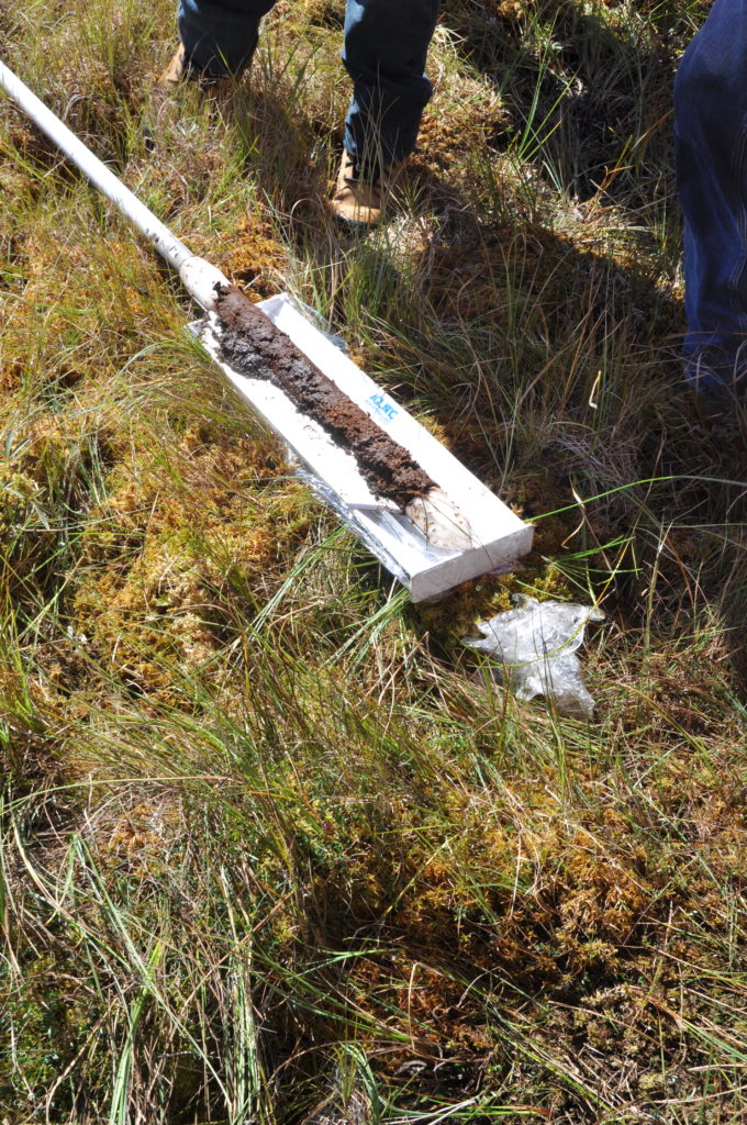
Each sample was carefully removed, measured and photographed. Practicing these steps in person was extremely useful, as we quickly learned this process wasn’t always as simple as it appears on paper. After extracting a few samples containing more water than peat, we found our rhythm and were able to extract several cores from various depths.
Ideally, all of the samples would be collected up to a depth of 2 metres, because this would provide us with a better understanding of how carbon content varies across depths, with the general expectation that the deeper the sample, the more carbon will be found. However, this isn’t always possible due to the physical landscape of a sample site — it’s hard to predict where there will be large rocks underground.
Following our work in the field, we returned to the classroom once again to plan future field surveys and the process of packaging the cores so they can be transported to the University of Toronto, where scientists will analyze how much carbon is stored in each sample.
Next steps
There are many ways this process can serve Indigenous nations and communities. It could be a first step toward a Carbon Guardians program which, like successful Indigenous Guardians’ programs, would support community efforts to steward the land.
A Carbon Guardians program would include specific work to measure and monitor carbon, providing both a baseline of carbon stored in the region and data as carbon is gained or lost. It will also likely add new data to support the Mushkegowuk Council’s call, based on Indigenous knowledge, for a mining moratorium in the Ring of Fire region.
Sampling, and the associated refinement of data in the carbon map study, has huge potential for supporting actions to meet Canada’s climate change commitments. But there is much that needs to be done at the policy level to bring that potential to life. Find out more about our recommendations for governments here.
With the ground now frozen in Ontario’s north, we are in the midst of planning field sampling surveys for the coming spring and summer months. This will provide much needed data in the Hudson and James Bay Lowlands.
