Using satellites and AI to help communities steward their carbon stocks
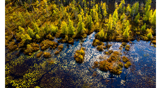
Nature sequesters and stores carbon in its plants and soils, so we know that protecting, managing and restoring these natural habitats helps us fight climate change. But it hasn’t always been easy to measure how much carbon is being captured by nature over time so that we can prioritize the most effective actions in the most impactful places.
Approaches to date have been costly, labour and time intensive, or have delivered incomplete data. That’s why WWF-Canada’s Nature x Carbon Tech Challenge granted three $100,000 awards for the most cost-effective, innovative and user-friendly technologies to measure carbon in nature.
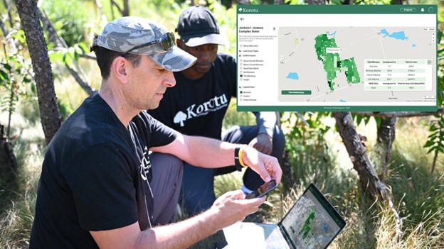
Korotu Technology, one of the three recipients, helps communities protect natural areas to support climate and biodiversity. Using optical sensors and satellite-based LiDAR (light detection and ranging), their LandSteward platform continuously monitors and measures forests, wetlands and grasslands to estimate and visualize carbon stock heat maps.
WWF-Canada spoke to Korotu’s co-founders, CEO Sean Rudd and Agata Rudd, who are bringing more than 35 years of experience in technology, finance and sustainability to help solve this problem
What is your technology all about and how does it work?
The product that we’ve been working on is called LandSteward, named after the people that we hope to empower from many different areas — those doing active management on the ground itself, whether they’re an Indigenous group, municipality, private individuals or mission-aligned corporations. We also work with conservation groups like WWF-Canada and farming groups that are interested in managing land for both production and conservation.
In a nutshell, we take data from satellites in space and we process it in-house using our own artificial intelligence. In this way, we derive meaning from the data and then we provide that information back to these land stewards. Our broad goal is to empower land stewards to be able to protect those lands better than they can today. A lot of that work helps answer questions such as: How much carbon is that forest storing? What was the impact of the wind storms, wildfires or other disturbances? How have restoration efforts impacted the area?
What makes it accessible and easy to use?
We thought very hard about the data sources that are available, and while we collect data through on-the-ground monitoring and drones (these are important and can play a key role), we’ve prioritized satellites because of the wide-ranging amount of data that can be gathered.
One of the reasons we chose to use satellites was because they’re ubiquitous in terms of coverage. We can cover vast spatial extents, at regular time intervals, and we can keep data collection costs low.
The other thing we’ve given a lot of thought to is the user experience. Our users don’t need to be experts in geospatial technology. Our user-centred design allows an individual to get started and very quickly get meaningful results that they can share with others.
Transparency and credibility are another priority. Sometimes with AI-based algorithms, it can be a little bit of a black box, and it can be hard to tell where the data came from, and therefore to have confidence in the results. So, we can explain where the data came from and how the results are derived.
Finally, we realize the importance of data ownership, control, access, and possession to many users, including Indigenous groups, and we are designing the software in a way that allows the user groups to control how the information is accessed and used.
What kind of benefit will your technology have for climate change?
Canada is home to 9 per cent of the world’s forests, and these forests provide a critical store of carbon as well as essential habitat for many species, including caribou.
Managing these forests well requires understanding the changing states of these forests, and Korotu’s technology makes it possible to estimate carbon over very large areas, at a high degree of accuracy, in a very short period. This helps support management decisions including where to focus attention on protection efforts (such as old-growth forests) while supporting continued use in others (such as for local timber production).
We hope that this data will be incorporated into policy decisions such as areas to include in Canada’s “30 by 30” commitment to protect 30 per cent of land and water by 2030.
How did the Nature x Carbon Tech Challenge help you achieve success?
It’s been wonderful working with WWF. The challenge is focused on validating the technology, including the accuracy of the data and the user experience, and gave us this extra impetus to bring both of those things to the foreground and do the validation work to make sure that we can get the accuracy that we need.
A second related benefit of the challenge is that it gave us wider exposure to different groups. It’s very helpful to have a conservation group like WWF assess the technology and be able to say that this is worth looking at — as a small organization that’s invaluable.
What does the future look like for your tech?
Our goal with this technology is to make it available to a really broad range of users. That’s one thing we will be striving to do in the year ahead: getting this tool into the hands of more communities. Recognizing that local conditions vary and allowing users to be able to input their data and make adjustments based on what they’re seeing on the ground in their forests and their communities — that’s been a key thing that we’re working on as well.
