New maps reveal dramatic decline of an Arctic caribou migration range
By Janey Fugate, project manager for the Global Initiative on Ungulate Migration
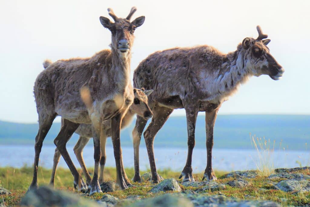
For centuries, the migrations of massive herds of caribou defined the ecosystem and lifeways of Indigenous people across the vast Canadian Arctic. These migratory caribou have made landscapes more ecologically rich, provided a prey base for the region’s carnivores and shaped the culture of the Indigenous communities that have harvested them for countless generations.
The Bathurst herd of barren-ground caribou, named for their historic calving grounds near Bathurst Inlet, once ranged from Nunavut all the way to northern Saskatchewan, with some individuals travelling over 500 kilometres on their yearly migrations.
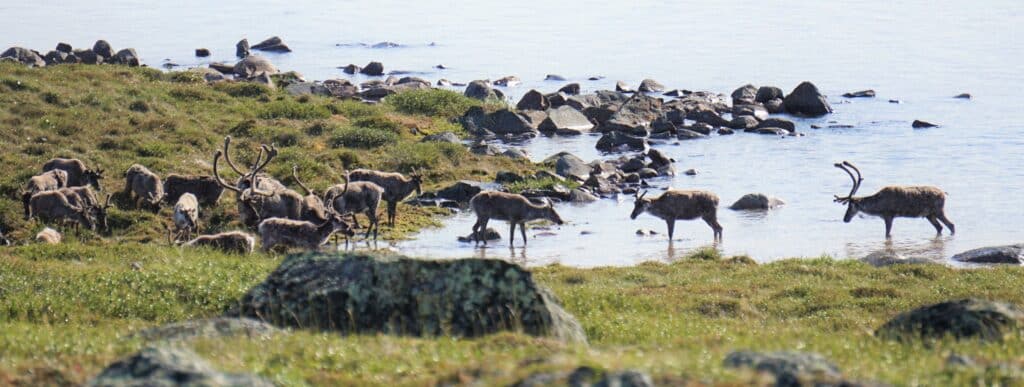
Today, these migrations — and the large herds they sustain — are hanging in the balance. The Bathurst caribou population has declined from 400,000 in the 1980s to less than 4,000 in 2025, according to new surveys by the government of the Northwest Territories.
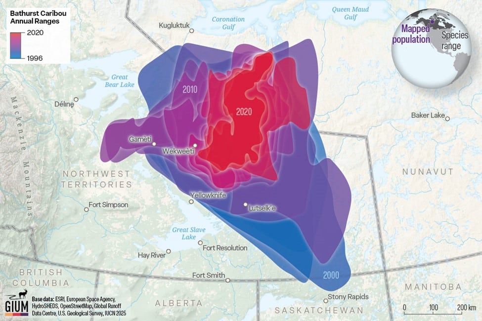
But it’s not just their numbers that are dwindling. Their migratory range has contracted as a result. New detailed maps reveal both the dramatic extent of their movements and the recent toll that human development and other factors facing the Arctic have had on the long-distance movements of the Bathurst caribou.
WWF-supported researchers partnered with the Global Initiative on Ungulate Migration (GIUM), an international team of migration researchers dedicated to conserving the world’s migratory ungulates — hoofed mammals that include elk, gazelles, wildebeests and zebras — to map how the caribou migration has been altered.
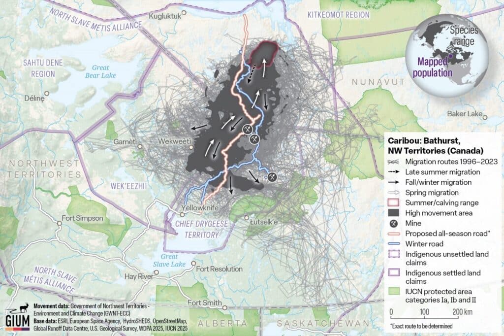
Long-term tracking data has enabled researchers to visualize the steady decline of the Bathurst caribou’s migratory range over the last 30 years. A variety of factors, which are difficult to disentangle, have impacted the herd and its movements.
Published in the Atlas of Ungulate Migration, a global effort to make migration maps publicly available for land-use planning and development, the Bathurst maps document areas that are critical for the remaining caribou. They also illustrate imminent threats.
Wildlife scientist Elie Gurarie, an assistant professor at SUNY in New York, has studied barren-ground caribou, the Bathurst caribou for the last 10 years. He says the maps bring a renewed focus to the plight of the caribou.
“This project shows how interconnected and collaborative ecological science and conservation are in the Arctic,” says Gurarie. “Mapping the Bathurst caribou herd isn’t just about lines on a map. It’s about understanding a species whose vast habitats are beginning to fragment, the pressures from roads and mines, and the cultural and material significance these animals hold for Indigenous communities.”
A road runs through it
It is increasingly urgent to identify and map critical areas for the caribou’s lifecycle as new development is slated for the area — part of the recently designated Arctic Economic and Security Corridor. The Gray’s Bay Port and Road project, a central element of the corridor, will connect current and potential mineral mines to newly accessible deep seaports via an all-season road.
The project has received heightened attention from the Canadian government, with the prime minister recently adding this initiative to his list of “nation-building projects,” meaning it may be fast-tracked for resource mobilization.
The new maps illustrate where the proposed all-season road will cut straight through the Bathurst caribou’s core migration area, passing very close to the herd’s calving grounds and effectively bisecting their current range. Three diamond mines already operate in areas known to be preferred by the herd.
Indigenous stewards and researchers have documented large-scale caribou avoidance of these areas, as well as the almost complete impermeability of the winter ice roads that service the mines. All of this could lead to further losses.
However, caribou tracking data and detailed maps make it possible to plan development so that it doesn’t disrupt seasonal migrations. If new development is built in the right places and in the right ways, researchers believe it doesn’t have to spell the end of the Arctic’s caribou migrations.
Indigenous-led restoration and management
The caribou herds of the Arctic are one of the only wild, migratory ungulate populations in the world to which Indigenous communities still maintain strong traditional ties — caribou are used for food and clothing and have shaped Indigenous cultures around the global Arctic and sub-Arctic regions. Their migrations are among the longest ungulate movements in the world.
“The steep decline of the Bathurst herd is not just a biological concern. It represents a profound cultural and ecological loss,” says Orna Phelan, a wildlife biologist with the North Slave Metís Alliance (NMSA).
As one of the Indigenous communities that stewards the caribou, NMSA has said that conserving this herd also means safeguarding their history, their identity and the health of the land we all share.
The Bathurst herd is emblematic of the pressures facing migratory caribou worldwide — as a species, barren-ground caribou have declined by 65 per cent over the last 20–30 years.
They face many threats: rising temperatures from climate change and an associated increase in insect harassment, which can threaten their survival. They also have access to poorer quality vegetation and see more frequent rain-on-snow events that make lichen — their primary winter food source — inaccessible under thick ice.
In the Bathurst’s migratory range, Indigenous-led guardians, harnessing traditional knowledge and on-the-ground observations, are intensively monitoring traffic and caribou behaviour on and around roads and mines.
Working in close partnership, Gurarie and colleagues are trying to understand how the caribou are responding to various kinds and levels of disturbance, with an eye toward specific mitigation solutions that can make linear infrastructure such as roads more caribou-friendly.
Mapping methods tested in the Bathurst caribou’s range could prove useful for the other large caribou herds that still inhabit the circumpolar North, allowing other regions to avoid stark population declines and to preserve the long-distance movements caribou require.
“Among all the caribou’s astonishing adaptations to not only survive, but thrive, in the Arctic, perhaps none is more important than the ability to move freely across large landscapes,” says Gurarie.
“By working closely with First Nations, Inuit, territorial governments and NGOs, we’re not only documenting change but working on shaping solutions.”
