Calculating ecosystem carbon down to the tree level
We know that protecting, managing and restoring habitats (also referred to as Nature-based climate solutions, or NbCS) can help us fight climate change by reducing carbon in the atmosphere.
But until we can measure how much carbon is captured by nature over time, we don’t know which conservation efforts to invest in or prioritize — and where to take these actions — to deliver the biggest benefit to the climate.
A variety of approaches for carbon measurement already exist, but they often deliver incomplete data and are costly and/or labour and time intensive. That’s why WWF-Canada’s Nature x Carbon Tech Challenge called on academics, entrepreneurs and inventors to pitch their most cost-effective, innovative and user-friendly technologies to measure carbon in nature.
Last year, we announced three award recipients of the challenge, who were awarded $100,000 each to work on their technologies. WWF-Canada spoke to B.C.-based Garrett Whitworth, director at Innovatree Carbon Group Ltd., to find out more about Innovatree’s new technology that will help to estimate the amount of carbon in forests.
How does your technology work?
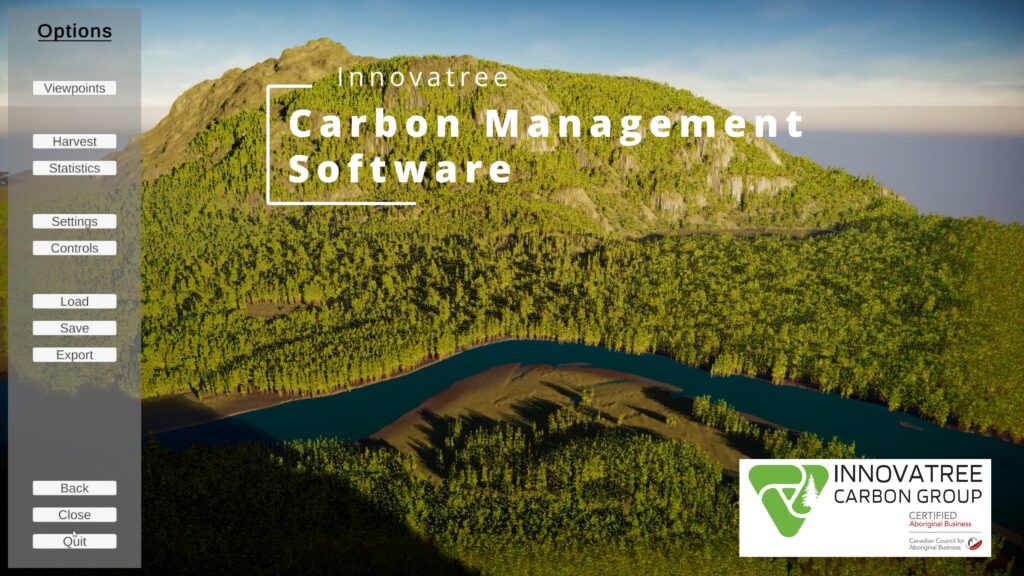
The Innovatree software relies on LiDAR (light detection and ranging) data and machine learning to calculate the carbon found in forests — down to the individual tree level.
Our software uses either publicly or privately available LiDAR databases that are typically collected from planes, and individual tree (or single-stem) identification software that we’ve developed. Once we’ve got the identification completed, the software uses nationally validated allometric equations to assign a carbon value to every individual tree across the landscape.
Allometric equations provide total biomass — the volume of aboveground tree parts like leaves, branches, etc. — estimates based on diameter at breast height (DBH, which is the width of a tree at chest height) and overall height.
The LiDAR data uses our single-stem identification and from that we can get tree height, crown areas and estimated DBH of the tree, which we can plug into the national equations that will generate an estimate of carbon content at the single tree level across entire forest landscapes.
What makes the technology accessible and easy to use?
We’re based out of B.C. and chunks of the province are already covered in LiDAR — these are publicly available datasets. The government is committed to capturing full provincial coverage within the next five or six years.
Other provinces in Canada, such as Alberta, as well as European countries have wall-to-wall LiDAR coverage. LiDAR is becoming more and more common, particularly with the importance of forest carbon.
The data is available and converting that into something that’s usable from a forest carbon perspective is what our software is doing — it’s making it simpler for people to understand what the data is actually saying and providing additional value to that data.
Where will it be used?
We’re looking to grow outside of B.C. and into other parts of North America. The software is being validated to work in areas with more of a Northern Hemisphere forest type — with coniferous and deciduous trees.
What kind of benefit will the technology have for climate change?
The primary benefit is the accurate, large-scale carbon modelling for project development. The technology gives an unbiased, verifiable dataset to the forest management and forest carbon project sector. This allows for better management of forests, particularly from a perspective of wanting to look at the amount of carbon that’s removed when harvesting or looking at, say, more sustainable harvesting methods like partial harvesting or fire-risk mitigation activities around First Nation communities and towns.
How did the Nature x Carbon Tech Challenge help you achieve success?
There are a lot of ways that the Challenge helped us, including having funds to go out and develop the software further and complete the validation steps that we need to do out in the field. Our software doesn’t just rely on remote sensing data — we also go and collect ground-truthing data to correct the data that’s being produced from the LiDAR. (Ground truthing is a process of checking modelling results against the real thing — in this case, the forest itself.)
Because there’s different growing conditions in different areas and different tree species, we feel strongly that it’s necessary to regularly collect ground-truthing data to make sure that we’re applying a correction factor — that’s relevant to each area that we’re in — to the software.
The Nature x Carbon Tech Challenge also helped the company gain mentorship from Microsoft, which helped us refine how to design our software from a visibility perspective.
The funding and connections that we made with others in the region through WWF-Canada has also allowed us to work on validating our software and provide data to First Nations communities about the forests in and around their territories.
What does the future look like for your technology?
In the second phase of the challenge, we’re going from analyzing primarily interior forests to more coastal forests. From there, we feel like we’ll move out of B.C., into Alberta, into the rest of Canada and North America.
The challenge was a great opportunity for us. As a small company that focuses more on research and development, having support in any capacity, whether it’s funding or expertise, is really beneficial and helps to move our tech forward quicker.